Utah Lake Shoreline Trail
The Utah Lake Commission is working towards a continuous, 14-city inclusive, multi-use recreational trail system that surrounds Utah Lake.
With the inception of the Commission came a master plan and vision statement for the lake itself:
“Utah Lake is a focal point of natural resource systems that contribute to the environmental health, economic prosperity and quality of life for area residents and visitors. Through collaborative restoration, protection and sustainable use efforts, the lake and its multiple-use amenities are fully recognized and enjoyed by current and future generations.”
One of those quality of life projects is the proposed Utah Lake Shoreline Trail. The current trail delineation proposes the length of the trail be 98.2 miles. Approximately 17.7 miles of trail have been completed, including segments in the cities of Saratoga Springs, Lehi, Vineyard, Orem and Provo. Another 17.7 miles are planned trails awaiting funding for final construction. These portions cover segments in the cities of Saratoga Springs, Lehi, American Fork, Lindon, Vineyard, Orem and Provo. When the latter segments are completed, there will be one continuous trail following the upper half of the lakeshore from Saratoga Springs to Provo, comprising of approximately 30% of the total mileage of the proposed Utah Lake Shoreline Trail.
Geographic Location
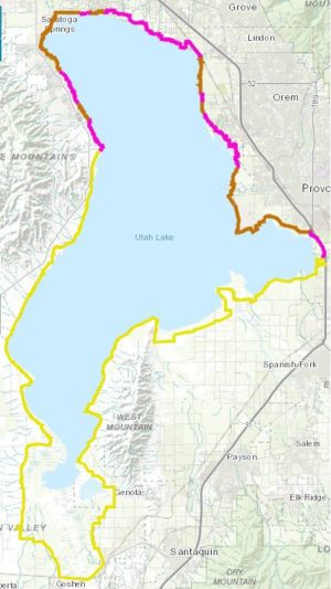
Brown= Existing trail
Pink= Planned trail
Yellow= Concept trail
Utah Lake is surrounded directly by 14 cities and towns, and is within less than an hour drive for all other cities in Utah County. The Utah Lake Shoreline Trail will follow the Utah Lake shoreline, and will travel through wetland areas and trail through some urban neighborhoods. Current portions of the Utah Lake Shoreline trail are already connected to Provo River Parkway, Murdock Canal and Jordan River regional trails. The Utah Lake State Park access point is only 4.2 miles to the Provo Frontrunner station, the Powell Slough access point is 1.3 miles away from the Orem Frontrunner station, and the American Fork Boat Harbor is only three miles away from the American Fork Frontrunner station. The location of the Utah Lake Shoreline Trail is within a 20-minute drive to Provo Canyon, the West Mountains, Lake Mountains and Traverse Mountains.
Why is it needed?
According to the projected statistics in population from the 2010 United States Census Bureau, as of July 1, 2016, Utah County was estimated to be home to 603,362 residents in 25 cities. That number represents 19.8% of the total Utah population.
The change in population in Utah County increased by 3% (17,668 people) from 2015-16. It is projected that by 2020, 234,765 (35% of the population in Utah County) will be children under the age of 18, with 73,790 of those children being under the age of 5. The Utah Lake Shoreline Trail will provide multiple health and wellness opportunities for the current and future generations.
Community Benefits
The location of the trail gives access to multiple land-based recreational opportunities in the canyons and mountains as well as water-based recreational opportunities on the lake’s 26 access points. There will be easier access to:
- Wasatch Mountain Range
- Traverse Mountains
- West Mountains
- Lake Mountains
Utah Lake as a whole will be easier to access for all communities the trail passes through, with many more communities and cities being able to access the trail with minimal motorized travel time. Many regional trails will tie into the Utah Lake Shoreline Trail as well:
- The Provo River Parkway Trail runs 6.8 miles from Vivian Park up Provo Canyon to the Utah Lake State Park, tying into existing portions of the Utah Lake Shoreline Trail
- The 17-mile long Murdock Canal trail travels from Timpanogos Highway in Lehi and intersects with a multi-use path in Orem that will tie into a proposed multi-use path leading directly to the Utah Lake Shoreline Trail
- The Jordan River Parkway Trail runs from the Legacy Nature Preserve in Bountiful and travels 40 miles south to connect to the Utah Lake Shoreline Trail at Inlet Park in Saratoga Springs
What does the trail look like now?
Here is our online map of the Utah Lake Shoreline Trail:
What’s being done to get it finished?
In June 2017, the Commission applied for the Rivers, Trails and Conservation Assistance Program grant through the National Park Service as a way to more fully plan, fund and implement the shoreline trail.
“Our national network of conservation and recreation planning professionals partner with community groups, nonprofits, tribes, and state and local governments to design trails and parks, conserve and improve access to rivers, protect special places, and create recreation opportunities.” -National Park Service
The Utah Lake Commission has before and will continue working closely with Mountainland Association of Governments, Utah County and the individual cities therein on establishing the trail delineation for the Utah Lake Shoreline Trail. We will announce updates on the trail as they come.
Join our mailing list for updates on lake improvements, things to do, events, news, and so much more!
Is there a timeline for the planned (pink) portions of the trail?
Each of those sections is being planned by a different municipality, hence each has a different timeline that fits that municipality’s funding and logistics.
Is there a way to donate time or funds to help complete this trail?
Jacob,
Thanks for the comment of support! Since there are multiple municipalities that surround Utah Lake, this trail will be a aggregation of city trails completed along the lake shoreline. As such, each section has its own timeline for completion, sources of funding, ownership, possible delays, etc. The Commission is working with the various municipalities and the county to collaborate on the project. Our recommendation would be to reach out to your municipality to urge progress on the trails in your area that are a part of this plan. The idea of volunteering has appeal, and we will include that in our discussions with the cities to see if they want to partner on a volunteer opportunity. Thanks for the idea!